Cadastre of Landslides of the Federation of Bosnia and Herzegovina


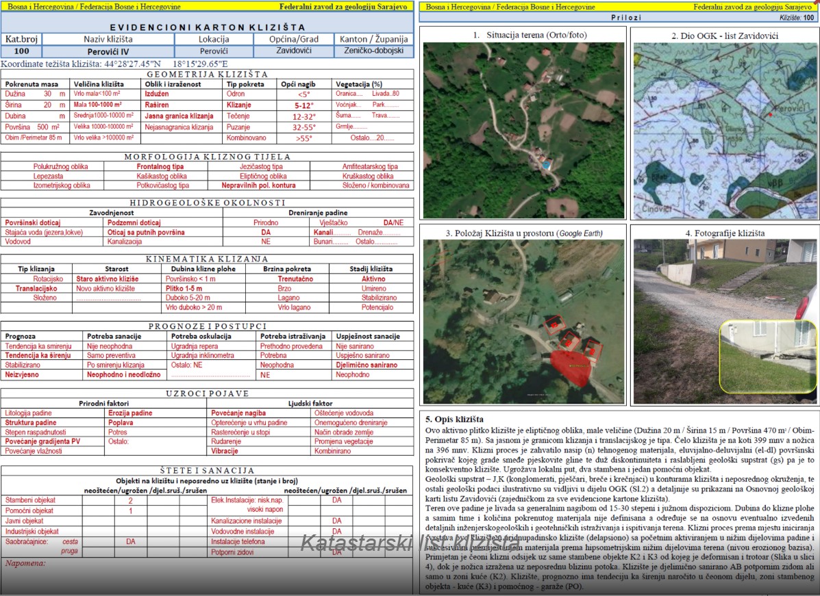
The Cadastre of Landslides of the Federation of Bosnia and Herzegovina represents a central database of registered landslides within the territory of the Federation of BiH. The cadastre is maintained and regularly updated by the Federal Institute for Geology, based on field investigations carried out in cooperation with the competent institutions. It contains information on the location, spatial extent, type, and dynamics of landslides, as well as risk assessment data. The objective of the cadastre is to monitor conditions, plan protective measures, and reduce landslide risk in the Federation of BiH.
skup podataka
https://registri.ippfbih.gov.ba/registri_ipp/
Bosanski, Hrvatski, Srpski
Okoliš
GEMET - INSPIRE themes, version 1.0:

 Spatial scope:
GeoERA Keyword Thesaurus:
FZZG Geoscientific themes:
HVD category:
HVD category:
HVD category:
HVD category:
HVD category:
HVD category:
HVD category:
Spatial scope:
GeoERA Keyword Thesaurus:
FZZG Geoscientific themes:
HVD category:
HVD category:
HVD category:
HVD category:
HVD category:
HVD category:
HVD category:
Slobodno:
landslides
FB&H
cadastre
15.729,
42.555,
19.624,
45.276
kreacija: 2023
2023
-
sada
vektor, tekstualna tabela
The Landslide Cadastre has been established for the systematic collection, recording, and monitoring of landslides within the territory of the Federation of BiH. Data from the cadastre serve as a professional basis for risk assessment, planning of protective measures, spatial management, decision-making in planning and projects, as well as for research and educational purposes. The goal is to reduce damage and landslide risk through timely monitoring and appropriate planning.
Geological Survey of the FBiH
Vedad Demir
Ustanička 11,
Ilidža, Sarajevo,
71210,
Bosna i Hercegovina
tel: +38733483365
email:
vedad.demir@fzzg.gov.ba
Uloga: vlasnik
Kvalitet podataka
Landslide data were collected through fieldwork conducted by an expert team, during which a standardized cadastral form is completed for each location, and spatial coordinates along with basic geological-engineering characteristics are recorded on site. The collected data are subsequently processed in the office, verified, and entered into Geographic Information Systems (GIS), where additional analysis, classification, and cartographic presentation are carried out. The process includes accuracy verification, data completion, and harmonization with the applicable technical standards of the Federal Institute for Geology.
Ekvivalentna razmjera:
1:
1
Ograničenja
Use and access to data in accordance with the applicable regulations and practices of the Geological survery of Federation of Bosnia and Herzegovina.
Vector data have restricted use and are provided upon request.
Metapodaci o metapodacima
69a181de-fc60-4c36-94f5-15e7b0a010e92
Geological Survey of the FBiH
Maida Zejnic
Ustanička 11,
Ilidža, Sarajevo,
71210,
Bosna i Hercegovina
tel: +38733483368
email:
maida.zejnic@fzzg.gov.ba
Uloga: kontakt tačka
2026-05-12