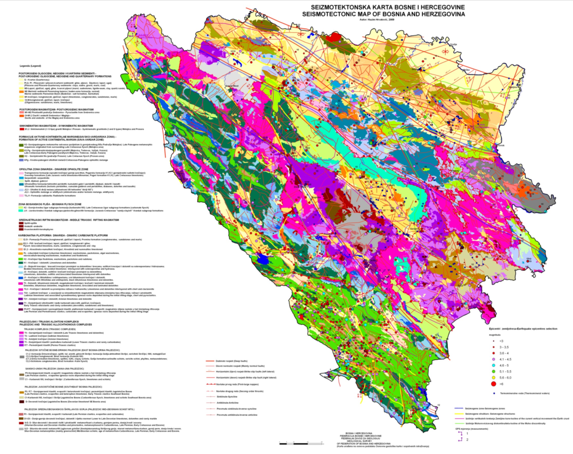
Seismotectonic map of Bosnia and Herzegovina


The Seismotectonic Map of Bosnia and Herzegovina is a thematic cartographic representation of the spatial distribution of active faults, seismic zones, and major tectonic structures within the territory of Bosnia and Herzegovina. The map integrates geological, tectonic, and seismological data in order to identify areas of increased seismic activity and to support seismic hazard assessment. The data are based on long-term geological investigations, instrumental and historical earthquake records, and the analysis of the regional tectonic framework of the Dinarides. The Seismotectonic Map serves as a professional basis for spatial planning, the design of infrastructure and energy facilities, risk assessment, as well as for scientific research and civil protection purposes. The map is intended for institutions, experts in the fields of geology, geophysics, civil engineering, and spatial planning, as well as for other users requiring reliable data on seismic activity and tectonic characteristics of the territory of Bosnia and Herzegovina.
skup podataka
Bosanski, Engleski
Okoliš
GEMET - INSPIRE themes, version 1.0:

 Spatial scope:
GeoERA Keyword Thesaurus:
FZZG Geoscientific themes:
HVD category:
HVD category:
Spatial scope:
GeoERA Keyword Thesaurus:
FZZG Geoscientific themes:
HVD category:
HVD category:
Slobodno:
seismotectonics
earthquake
geology
geophysics
geohazards
Bosnia and Herzegovina
15.729,
42.555,
19.624,
45.276
publikacija: 2009
The purpose of the Seismotectonic Map of Bosnia and Herzegovina is to identify, analyze, and cartographically represent active tectonic structures and seismic zones in order to assess seismic hazard and reduce seismic risk. The map serves as a professional basis for spatial and urban planning, as well as for the design and construction of infrastructure, energy facilities, and other public-interest structures. The document provides a reference foundation for seismic hazard and risk studies, civil protection and emergency planning, and for scientific and professional research in the fields of geology, geophysics, and engineering seismology. It also enables competent authorities to make informed decisions in land management and sustainable development, taking into account natural geodynamic processes.
Geological Survey of the FBiH
Vedad Demir
Ustanička 11,
Ilidža, Sarajevo,
71210,
Bosna i Hercegovina
tel: +38733483365
email:
vedad.demir@fzzg.gov.ba
Uloga: autor
Kvalitet podataka
The Seismotectonic Map of Bosnia and Herzegovina was prepared in 2009 by Hazim Hrvatović. The map was developed on the basis of data from the Basic Geological Map (OGK) at a scale of 1:100,000, which includes detailed lithostratigraphic, structural-tectonic, and engineering-geological interpretations of the terrain, as well as on the results of the author’s own field and desk research. The preparation of the map relied on existing geological and tectonic base maps, data on fault structures, regional and local tectonic units, and analyses of the seismicity of the territory of Bosnia and Herzegovina. Through the integration of cartographic sources, structural analyses, and the interpretation of seismological data, a seismotectonic reinterpretation of the area was carried out in order to more precisely define active structures and seismic zones. The data were professionally processed, systematized, and cartographically presented in accordance with established methodological principles of geological and seismotectonic mapping.
Ograničenja
Use and access to data in accordance with the applicable regulations and practices of the Geological Survey of the Federation.
Vector data have restricted use and are issued upon request.
Metapodaci o metapodacima
69a6ef60-ba10-4cf0-99d0-1b0840a010e92
Geological Survey of the FBiH
Maida Zejnic
Ustanička 11,
Ilidža, Sarajevo,
71210,
Bosna i Hercegovina
tel: +38733483368
email:
metadata@fzzg.gov.ba
Uloga: kontakt tačka
2026-03-03