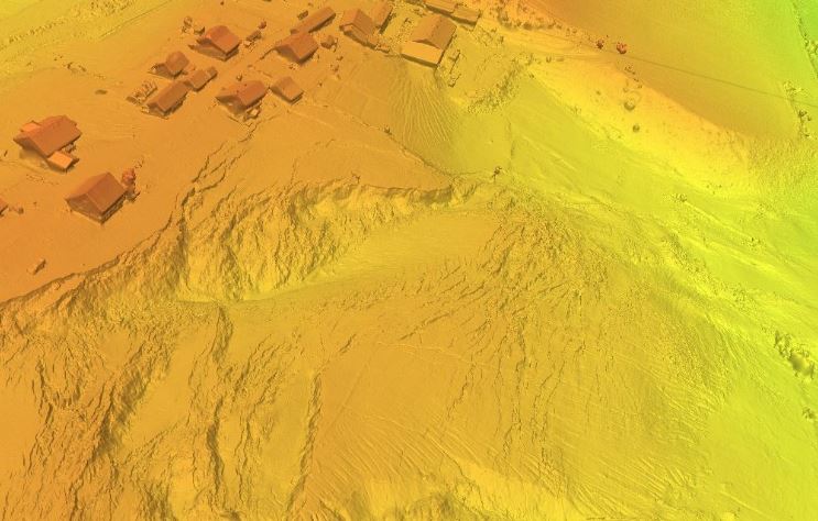
Digital Terrain Model of the Mladoševica landslide in Novi Šeher


The model provides a detailed representation of the spatial morphology of the terrain and the characteristics of the area affected by the landslide. The data enable the analysis of the landslide geometry, extent, and morphological features, as well as the monitoring of spatial changes. The resource is intended for geological and geotechnical research, landslide hazard and risk assessment, planning of remediation activities, and supporting spatial management and expert decision-making.
skup podataka
Bosanski, Hrvatski, Engleski
Okoliš
Planiranje/Katastar
Planiranje/Katastar
GEMET - INSPIRE themes, version 1.0:
 Spatial scope:
FZZG Geoscientific themes:
HVD category:
HVD category:
HVD category:
Spatial scope:
FZZG Geoscientific themes:
HVD category:
HVD category:
HVD category:
Slobodno:
fzzg
Mladoševica
landslide
digital terrain model
15.729,
42.555,
19.624,
45.276
kreacija:
2025
grid
The Digital Terrain Model of the Mladoševica landslide in Novi Šeher was developed to provide a detailed representation of the terrain morphology and to support the analysis of landslide characteristics. The data are intended for geological and geotechnical investigations, landslide hazard and risk assessment, planning and monitoring of remediation measures, and as support for spatial planning and natural hazard risk management.
Vedad Demir
Ustanička 11,
Ilidža, Sarajevo,
71210,
Bosna i Hercegovina
tel: +38733483365
email:
vedad.demir@fzzg.gov.ba
Uloga: čuvar
Kvalitet podataka
The Digital Terrain Model of the Mladoševica landslide was produced based on an aerial photogrammetric survey conducted by the Federal Institute for Geology using a Quantum Systems Trinity Pro unmanned aerial vehicle (UAV). The survey was carried out as part of the activities related to the preparation of the landslide remediation project. The data were processed using standard photogrammetric procedures to generate an accurate and reliable terrain model.
Ograničenja
Use and access to the data are subject to the applicable regulations and practices of the Federal Institute for Geology.
Vector data have restricted use and are provided upon request.
Metapodaci o metapodacima
6a31410a-0154-4f29-8451-c72c60a010e92
Maida Zejnic
Ustanička 11,
Ilidža, Sarajevo,
71210,
Bosna i Hercegovina
tel: +38733483368
email:
maida.zejnic@fzzg.gov.ba
Uloga: kontakt tačka
2026-06-16